
Europe’s best-kept secret, the Faroe Islands, situated halfway between north-west Scotland and Iceland, is one of the world’s most idyllic places magically embedded in long green valleys, imposing cliffs, and dream-like landscapes. The archipelago is such a hard-to-reach destination that not even Google’s charting teams have ever been there, which is why the semi-autonomous territory of Denmark had remained neglected by the tech giant’s mapping feature, Street View.
This scenario changed recently, when a fellow Faroe-Islander, Durita Dahl Andreassen of Visit Faroe Islands tourism agency, decided to map the islands by herself to show Google what they were missing out. In her mission to get the island’s population on the Street View map, she was supported by the Liquidminds agency and got some extra help from a handful of cute woolly companions.
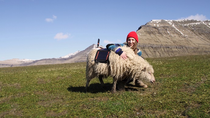
This week’s #ThrowBrandThursday features Durita and her exciting journey to document the islands for Street View. She started her ambitious project in April 2016, named it “Sheep View 360,” and chose five sheep as camera operators. Given that the archipelago’s name means “Sheep Islands” and the place hosts over 70,000 sheep — almost as twice as the islands’ population — her cartographic plan wasn’t unreachable at all.
The idea that sparked inside Durita’s mind began to take shape in June when, along with a local shepherd and an inventor, she equipped her first sheep with a solar-powered, 360-degree camera. With a new ‘outfit,’ the sheep was left to roam freely on the green hills and volcanic rocks of the archipelago. As the sheep kept walking around, the camera captured panoramic photos, which were sent back to Durita, who uploaded the imagery to Google Street View.
The team managed to map five locations of the island, but to successfully finish their project, they still needed Google’s helps. So, they launched an online petition, urging the tech giant to put the archipelago on Street View.
In a matter of days, the request became viral, drawing the attention of the international press from Asia to South America. “This campaign has already generated more awareness than the solar eclipse,” said the company’s director, Guðrið Højgaard. Yet, this wasn’t enough. The ultimate goal was to make Google aware of the initiative.
The company’s feedback did not cease to appear. Once Google heard of the brilliant campaign, they sent a team to help the community capture even more images. But rather than helping the locals with its traditional Google Street View car, the Mountain View-based company supported the project with 360-degree cameras and a Trekker, as part of their Street View camera loan program.
With all the necessary resources at hand, the real challenge was still ahead of them. To achieve a better result, Durita invited tourists or residents to stop by Visit Faroe Islands’ office or by Atlantic Airways, borrow a camera, and join the program. The offer still stands, so if you are traveling to the Faroe Islands anytime soon, you can update their map with your own personal imagery.
The award-winning campaign achieved remarkable results: it reached to a wide audience of over 2 billion people, had over 42,000 webpage mentions, and was featured in over 7,000 news stories. With zero media spending, the project achieved its goal, namely to promote the archipelago as a picturesque tourist attraction. Thousands of people visited the islands and filled the hotel rooms during the campaign’s apogee. What are you waiting for?